
RINEX files
Receiver INdependent EXchange format files contain raw satellite navigation system data relative to a specified interval of time (typically one calendar day). They allow users to add corrections to their data in post-processing, improving its accuracy.
The standard name format for version 2 of RINEX files is: ssssdddh.yyt, where:
- ssss is a the marker name of the ground station where the recording was performed.
- ddd is a three digits number indicating the day of the year when the recording started.
- h is a letter indicating the hour of the day when the recording started.
- yy is a two digits number indicating the year when the recording started.
- t is a letter indicating the type of the RINEX file. Most common types are:
- .**o files: observation data files, contain satellites position data.
- .**d files: compressed observation data files.
- .**n files: navigation data files, contain GPS ephemeris data.
- .**g files: navigation data files, contain GLONASS ephemeris data.
- .**l files: navigation data files, contain GALILEO ephemeris data.
- .**m files: meteorological data files.
RINEX files are typically available from networks of ground stations located at accurately surveyed positions and covering delimited geographical areas. Many countries have organisations running a network of ground stations and RINEX files are typically available on their websites.
Examples of these networks are:
- UK: Ordnance Survey (https://ordnancesurvey.co.uk)
- EU: EUREF (http://epncb.oma.be)
- USA: CORS (https://ngs.noaa.gov/CORS)
A RINEX file could also be downloaded directly from an RT-Base S station, following this procedure:
- Power the base station and connect it to the laptop using an Ethernet cable.
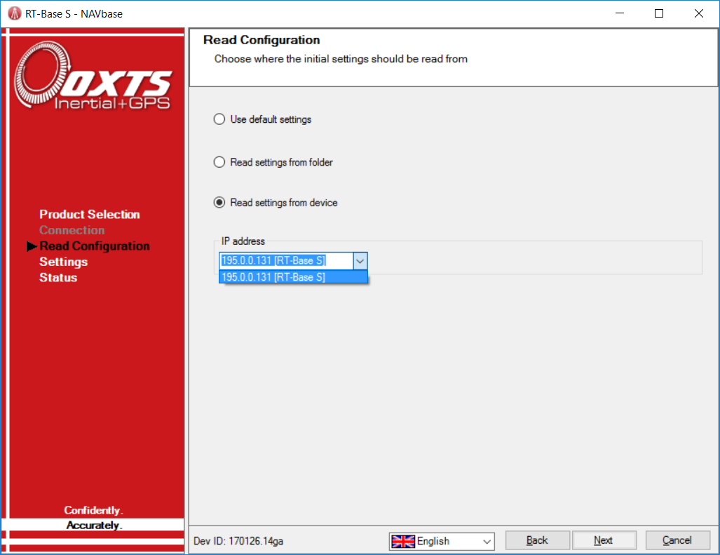
- Open NAVbase, select RT-Base S and click “next”.
- Select “Read settings from device” and select the appropriate IP address.
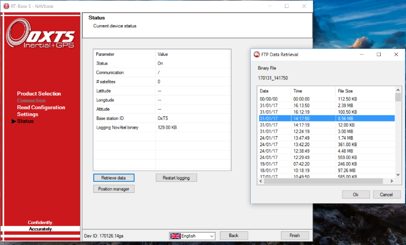
- In the “Status” page click on the “Retrieve data” button.
- In the new dialog box select the file to download and click “Ok”.
- When the download terminates, click “yes” in the new dialog window
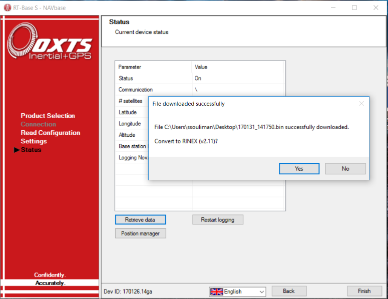
- Four files will be saved: a binary file and three different RINEX files with the following extensions: “.**g” (GLONASS ephemeris), “.**n” (GPS ephemeris) and “.**o” (satellites observations).
Processing RINEX files with RD files
In order to be utilised in post-processing to add differential corrections to the RD file data, RINEX files must meet some conditions on the format, version, time and type of data of the file. RTKLIB is an open source program package that allows to modify RINEX files and set them to meet required conditions.
The rtklib_2.4.2.zip version is available at: http://www.rtklib.com/.
RINEX files must meet the following four conditions to be processed with RD files:
- Be an “observation” (.**o) file: If the observation file is not directly available, it might be in the form of compressed observation (.**d) file. To be used in post processing, this file must be decompressed using the crx2rnx.exe program included in the RTKLIB package. Please refer to: http://sopac.ucsd.edu/hatanaka.shtml for further instructions.
- The interval of time covered by the RINEX file(s) recording must contain the interval of time during which the RD file has been recorded.
- If version 2, be of the 2.10 or 2.11 version. the rtkconv.exe program included in the RTKLIB package could be used to convert a RINEX file to the required version.
Software Configuration
RINEX files can be processed with RD files following this procedure:
- Save a copy of the RD file to a new folder and save a copy of the RINEX "observation" file(s) to a different folder.
- If available, save the "navigation" (.**n and .**g) files in the same folder as the "observation" file(s).
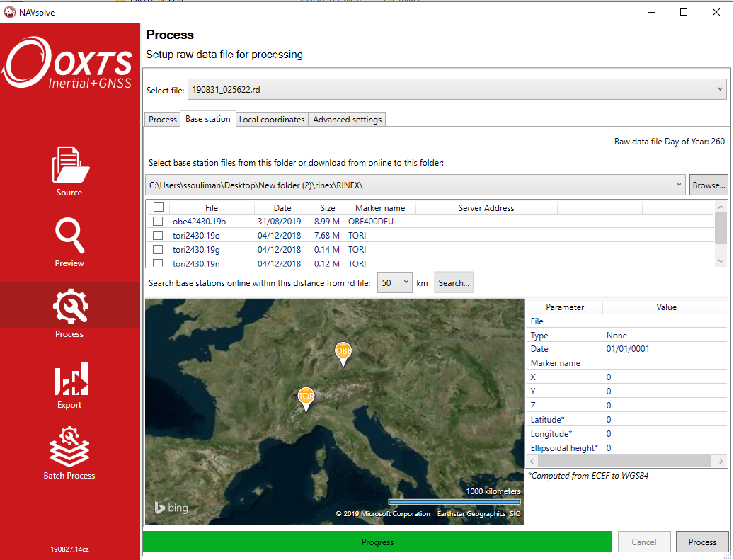
- Open the RD file with NAVsolve and go to the "Process" page.
- In the “Base station” tab:
- Browse to the Folder where the RINEX file(s) have been saved.
- Available files will be listed and the locations of base stations will be displayed on the map.
- Select the file(s) that you intend to use.
- Proceed with the usual processing procedure.
Comments
0 comments
Please sign in to leave a comment.